There are good ships and wood ships
And ships that sail the seas
But the best ships are the friendships
And may they ever be...

Saturday, March 31, 2012

In the Southern Hemisphere

Date: 03/30
Noon to noon run: 123 NM
Time of position: 00:25
Lat/Lon: 01 deg 18.57'S; 128 deg 34.98'W
Course: 220 deg Mag
Next Waypoint:    East end of Hiva Oa: 807 NM distance
                  09 deg 45.03S; 138 deg 45.65W
 
We are basically heading for the east end of Hiva Oa about 850NM away at the time of this writing (17:00 PV time).

The wind was light and out of the east this morning but grew in strength to about 10-15Kt and changed to the southeast which makes it feel like the trades so we've decided to go with it and head for the barn as it were.

GRIB files continue to underestimate wind strength and direction so they are not completely reliable. But they do show some lows which we've seen so there is some value there. The lates weather fax shows only one ITCZ, and that is north of the equator so we are comfortable that the ITCZ is no longer an issue. As we head southwest we have a line of small light puffy clouds coming in from the east, so we will se what changes in wind they bring, if any.

We are celebrating with a steak dinner tonight complete with potatoes and fresh vegies. Yes, we still have fresh vegies. We will also most likely open a good bottle of wine to celebrate. As we crossed the equator, we poured some good gin and good tequila for King Neptune and Davy Jones. And will probably give them another dram this evening.

All is well, and we have 3 happy sailors on board.  John

Friday, March 30, 2012

Moss Backs No Longer

Date: 03/29
Noon to noon run: 140 NM
Time of position: 00:00
Lat/Lon: 0 deg 08.64'N; 126 deg 34.93'W
Course: 220 deg Mag
Next Waypoint: East end of Hiva Oa: 937 NM distance
                   09 deg 45.03S; 138 deg 45.65W
 
We've been sailing close reach to close hauled all day with a nice 10-12 knot breeze out of the south southeast, and are closing in on the equator. When we cross the equator (which happened around 3-4 am), Bob and I will go from being moss backs to shell back. John D., having crossed the equator once earlier in his life is already a shell back. So according to custom he will play the role of King Neptune. Hmmm. I hope the king goes easy on us!

Since yesterday afternoon the seas have been long rolling swells arising from different directions, but the predominant swell is east south east - long, slow and powerful. For the past few nights on my watch, the moon having already set, the heaven has been filled from horizon to horizon with stars. At this latitude you have only to glance toward the north and south horizon to see both the north star and the southern cross - truly magnificant.

Tonight, however, there is an upper to mid layer of clouds obscuring the stars but the brightness of the moon still penetrates. By the time it sets the cloud layer will most likely be gone for the night. As high as the moon currently is overhead, it may well still be up when we cross the equator. Under these conditions I can not think of a better way to pass from the northern hemisphere to the southern hemisphere. Sure, it would be nice to cross the equator during daylight hours, but with such a sky, it is fine with me.

A gentle breeze, gently rising swells, a nearly half moon, and a balmy temperature. The only thing I'm missing is my sweetheart.

John

Thursday, March 29, 2012

Day 12

Date: 03/28
Noon to noon run: 145 NM
Time of position: 22:00
Lat/Lon: 02 deg 05.07'N; 125 deg 01.38'W
Course: 220 deg Mag
Next Waypoint:    East end of Hiva Oa: 1085 NM distance
                  09 deg 45.03S; 138 deg 45.65W

We downloaded a 48 Hr forecast yesterday mornning that predicted that the ITCZ (the Zone) would be in our general area of longitude (120-130W) and between 3 and 5N latitude so we headed approximately due south for 24 hrs. This morning upon entering the vicinity of 3N we started heading more westerly, but could see squall lines forming both N and S of us. The surface analysis we subsequently downloaded from our weather fax via sailmail showed 3 separate Zones. Ok, one is enough, two is too many, but 3? - Come on now, enough is enough!

Well, the weather will be what it will be, so we have to adapt. At 1:30 this afternoon we ran out of wind and started the iron genoa. We motored for about 2 hours heading south southwest and broke through that squall line to find fresh breeze and have been riding with that since. As for tomorrow? We'll see when the sun rises.

On a different subject, we have been using water from the port water tank and making water periodically which has meant that there has been ample water for us. We still haven't touched the 65 or so gallons in the starboard water tank.

That's it for now.  John

Tuesday, March 27, 2012

Through the ITCZ?

Date: 03/25\6
Noon to noon run: 136 NM
Time of position: 00:33
Lat/Lon: 05 deg 55.90'N; 123 deg 08.99'W
Course: 190 deg Mag
Next Waypoint: 0 deg N; 126 deg W

If the NOAA surface analysis is correct, we penetrated the "Zone" otherwise known as the ITCZ, or doldrums, last night at about 8 degrees north latitude, and exited this morning at about 6 degrees. In reality if it was the ITCZ we went through, it was probably only 1 degree wide (or about 60 miles) at the most, not 2 degrees as suggested by the surface analysis weather fax. But, hoping it was the ITCZ we don't care. Our plan right now is to get just plain south, before things change again. - And, it looks like we're doing that. At least so far. Here's how it went:

Analyzing a satellite photo a couple of days ago while on our way to our waypoint at 6N, 126W, it seemed that a small hole had opened in the ITCZ that we might squeeze through and perhaps we did. We changed course and headed more south than west anticipating it, but we weren't sure. Yesterday progressed with anticipation, and cloud signs growing. Then, on John's watch last night he saw plenty of lightening, seemingly all around us, in the various cloud formations. Then, on my 3-6AM watch, in a light breeze, we passed though multiple squalls with rain but no wind change in wind velocity or direction.

After I hit the rack this morning we passed into clear skies and the breeze picked up to 15Kts. As the afternoon progressed the skies grew to an ominous dark gray and the wind continued to build to over 25Kts. We put in a second reef just before cooking dinner. On my watch (9-Midnight) just finished  the winds have moderated to 10-15kts.

Todays GRIB file showed no evidence of winds higher that 10Kts in our area, although it showed barometric pressure at 1009 millibars for our area. I'd seen that number and the designation of a "Low Pressure" on yesterdays GRIB file forecast for today and reviewed it. A low was forecast for today at about 4 degrees North, and while it wasn't designated on today's GRIB file, it could be that the low was real, but 2 degrees further North.

In the end, here we are closing in on 5N, and making all the speed we can. - Sure hope I'm right and that the Zone is behind us rather than still waiting for us out there - Somewhere!

Monday, March 26, 2012

Almost Halfway

Date: 03/26
Noon to noon run: 142 NM
Time of position: o3:00
Lat/Lon: 07 deg 50.99'N; 112 deg 14.31'W
Course: 200 deg Mag
Next Waypoint: 0 deg N; 126 deg W

The ITCZ continues to keep moving so we've made a new waypoint.This one is at the equator. While we will adjust as conditions change, the waypoint is just under 600 NM away. Considering the new route configuration we will be half way in about another 164 miles. We got our first squall last night and just went through another one. Considering the heat and humidity they cool things off quite nicely. But, during the squall, with everything shut up down below is stifiling.

Sunday, March 25, 2012

Day 7 and 8

I've had some questions as to what I (Gail) am doing while John is sailing.  I'm in Tucson, AZ visiting my parents, getting last minute boat supplies, and doing taxes.  Not nearly as exciting as John's trip.  I'll fly to Tahiti from LA around April 15th and catch an inter-island flight to the Marquesas.


Date: 03/25      
Noon to noon run: 122 NM
Time of position: 03:00
Lat/Lon: 09 deg 31.13'N; 120 deg 39.36'W
Course: 210 deg Mag
Next Waypoint: 6 deg N; 126 deg W
Wind: Mostly broad reach to DDW at 7 - 15 knotS Avg boat speed 5-7 kts.

We have moved into the fringe of the ITCZ; actually we were on the fringe since yesterday morning.  And while we've seen multiple squalls around us, we've only received a tiny bit of rain so far, but that will most certainly change. We've been watching the ITCZ and there may be a really big hole opening up. If that happens we will probably dive straight south to get through as quickly as possible. Even after we get through the ITCZ the equator could still be a few days away.

Date: 03/24

Noon to noon run: 106 NM
Time of position: 19:00
Lat/Lon: 11 deg 52.87'N; 118 deg 14.85W
Course: 200 deg Mag
Next Waypoint: 6 deg N; 126 deg W
Wind: Mostly broad reach to DDW at 7 - 10 knots or less; Avg boat speed 4-6 kts.

Music is gybing its way down our course line to our waypoint (above).  We have about 566 NM to get there. Then we will be looking for a soft spot in the ITCZ which we've renamed "The Zone".Our weather guru friend, Simon, who was our navigator for Pacific Cup in 2008 is now keeping us up to date on the Zone. And, we're glad to have him in our hip pocket.
 

Friday, March 23, 2012

Day 6

Date: 03/23
Noon to noon run: 86 NM
Time of position: 18:11
Lat/Lon: 12 deg 58.77'N; 117 deg 04.7951'W
Course: 259 deg Mag
Next Waypoint: 6 deg N; 126 deg W
Wind: Mostly about 150 t0 DDW at 8 knots or less Avg boat speed 3-5 kts


Abrupt changes in the ITCZ yesterday have spun incredibly light winds into our entire area of sail. With our waypoint at 6 deg N and 126W still 675 NM away, and with the blanket of light winds over the entire area it seems our best option is just to stay the course for a day or two and see where we get and what changes in wind velocity and direction might occur. We can only sail at 245 and 195 at best so we will jibe from board to board to approximate our intended route as best we can given the conditions.

Emptied 4 jerry jugs of diesel into the fuel tank and it was nice to free up the deck space. Then we set up the rigging for the spinnaker pole on the port side, so now we can run wing on wing with genoa polled out on either side as needed.

Bob: All is well onboard, and John D continues to deliver hearty, scrumptious meals, as well as his wry humor we all expect and love!

Bye for Now, John

Thursday, March 22, 2012

Day 5

Date: 03/21
Noon to noon run: just over 150 NM
Time of position: 18:30
Lat/Lon: 13 deg 26.28'N; 115 deg 55.39'W
Course: 210 deg Mag
Next Waypoint: 6 deg N; 126 deg W
Wind: Mostly on our stbd stern at about 5+/- knots.

Although we've logged 150 nautical miles the last two days, today dawned with light and fluky winds which we've had all day so power production has really only been solar. As such I'm keeping this brief.

Love John

Note from Gail - we have many ways to charge the batteries to handle various conditions.  Solar works for sunny days.  If they have wind to sail we have a towing generator - it's basically an arm with a propeller that we lower into the water and it generates power as the blades of the prop spin.  But it won't work without wind.  We have the engine, but that uses precious diesel fuel.  And we have a Honda generator that uses gasoline.  So many options, but solar is the way to go if you have sun.  John is monitoring power consumption so they have plenty of battery power to run the refrigeration and the navigation equipment.  The SSB radio he uses to send me these emails uses alot of power to transmit so he's keeping the messages short to conserve.  Nothing to worry about.

Wednesday, March 21, 2012

Only 3,000 Miles To Go

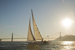
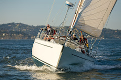
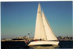
Hello Everyone - Music is off on her next adventure.  John and 2 crew are currently sailing Music to French Polynesia and the South Pacific.  They left Friday, March 16 and it will take approximately 3 weeks to get to the Marquesas.  I'll be flying over to meet them in mid-April.  His 2 crew did the Pacific Cup race, so everyone knows each other and the boat and they are all excellent sailors with alot of ocean experience. 

Following are the first few messages from John and I'll be posting regularly with new updates as I get them.

Date: 03/17
Time: 19:00
Lat/Lon: 18 deg 52.48' N; 107 deg 48.08' W
Course: 207 deg Mag
Next Waypoint: 6 deg N; 126 deg W

Persons Onboard:
John McCartney, Skipper
John Denny, Sea Chef & Crew
Bob Peters, Crew

Day 2, first full day on the water, and while the winds are light and fluky, with Cabo Correintes 150 nautical miles (NM) behind us, and Music moving smartly along close hauled at 6 knots in an apparent breeze of 12 knots as we are making dinner it seems we are making pretty good progress.

John D. saw a whale about 50 yards off to starboard late yesterday afternoon after leaving the Banderas Bay, and today we've seen lots of flying fish which appear to be getting bigger as we get out to sea.

We've also seen 2 seals floating on the surface sunning their bellies with up all four flippers out of the water like kids having some sort of contest to see who could hold their arms up the longest. It's an odd sight, and while we've seen this behavior before, it's always fun to whiteness. Additionally, John counted 6 sea turtles and one birdal, or bird standing on a turtle.

For dinner tonight we are subsisting on guacamole, heated taco shells, and camarones sautéed in garlic. John Denny promises to start fishing tomorrow. It could be worse - I could be doing the cooking. But then, and the crew would mutiny for sure.

Bye for Now,  Skipper John

Date: 03/19
Noon to noon run: 153 NM
Time: 21:00
Lat/Lon: 16 deg 09.77'N; 112 deg 06.52'W
Course: 215 - 220 deg Mag
Next Waypoint: 6 deg N; 126 deg W
Bearing to waypoint: 225 deg M
Wind: Mostly on our port beam at about 15+/- knots, having built early in the day from about 5 kts during the night.

Having established watches at 3 hours on and 6 hours off from the start, we seem to be settling into the routine of life at sea. Last night, just after dusk a really bright light appeared on the horizon to our stern. We surmised it was most likely a fishing boat, but there was no AIS signature so we'll never know. At the time we were approximately abeam of and about 100 NM south of Isla Socorro of the Islas Revillagigedo group. While the Revillagigedos are one of the few mile stones along this route to the Marquases they signal that we are truly away from Mexico and have begun a new adventure. It really feels good to have them behind us.

As the night progressed a light appeared on the opposite horizon, off our bow. After midnight, we could see that we were overtaking them. We hailed the suspected boat in our Puddle Jump fleet and found it to be s/v Cheers. We passed them sometime between 3 and 6AM this morning while John D. was at the helm. He claims with emphasis, "We didn't just pass them, we smoked them - tell it right!" So, I stand corrected and freely admit that we truly passed Cheers in fine style.

Winds today have been quite consistent and we've taken back the helm from our Monitor wind vane steering system, Monty. Why should Monty have all the fun while the winds are good and we enjoy driving? Our windvane was christened Monty during our return voyage to San Francisco from Oahu in 2008. That brings me to the number of steering systems we have onboard which total three. And while some of our yachting friends back in the San Francisco Bay Area seem shocked that autopilot is not one of them we get by just fine.

The three steering systems are hand, Monty, and string. You've heard of "string theory", and in vascular diagnosis we have a "string sign". Well, we onboard Music have "string steering". It works like this, when we are motoring with no wind, we tie a string (a heavy piece sail cord called leach line) to a padeye at the base of the helm steering wheel and secure it's two ends to spokes on opposite side of the wheel, thus keeping the boat on a relatively straight course despite the torque of propeller rotation. While we cannot just tie it and forget it like some yachties do when using autopilot steering, you should never do that when piloting a boat anyway.


Date: 03/20
Noon to noon run: 150 NM
Time of position: 19:30
Lat/Lon: 14 deg 41.30'N; 114 deg 06.51'W
Course: 210 deg Mag
Next Waypoint: 6 deg N; 126 deg W
Wind: Mostly on our stbd stern at about 10+/- knots apparent

The wind went well aft today and maintained a steady 15 Kts or so. So we set the genoa out on a pole and started sailing wing on wing. After some relatively unsuccessful attempts at getting the windvane to steer well with the winds so deep, we finally had unequivocal success just after dusk. I am truly impressed with the Monitor windvane steering system. It appears to work really well, even when steering quite deep on a broad reach, right almost to dead down wind, or DDW. Well, it's time to get some sleep now.

From all of us onboard Music, good night.

Skipper John