There are good ships and wood ships
And ships that sail the seas
But the best ships are the friendships
And may they ever be...

Monday, September 22, 2008

John's Home Safe and Sound 9/20 14:45PDT

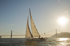
John's Home!!! He was about an hour ahead of schedule for his arrival and almost caught his greeting committee unprepared. But we rallied and had boats out on the water and around 30 people at the dock to welcome our wayward sailors home. I was able to climb aboard Music a short way before she arrived at the dock and it was marvelous to be able to sail into the slip with John and crew. Gail

John here; While we pulled into our slip at Marina Village on Alameda Island, at about 2:45 PM, we passed under the Golden Gate Bridge at 13:33 PDT on Saturday, 09/20, officially ending our return delivery from Kaneohe Bay, Oahu. Why the Golden Gate bridge? - Because our "delivery route" started upon exiting the Sampan Channel, leaving Kaneohe Bay and ended at the Golden Gate Bridge. Here are some statistics:
Length of delivery: 16 days, 19 hours, 13 minutes. Length of route: 2354 nautical miles; Crew: Scott Saulovich - outstanding helmsman, sea \chef; Steve Jacobsen - outstanding helmsman / fish filleter/ dorado grill meister; myself, John McCartney - skipper/navigator.

Thanks to all of you for your support during the race, throughout my extended stay on Oahu, and over the course of all three delivery attempts coming home!! The total distance I personally sailed trying to bring Music home was about 3800 - 3900 miles, including the returns to Oahu. Special thanks to my lovely wife and personal support - Gail Lapetina!!

Saturday, September 20, 2008

John's Almost Home!

Here's what we've been waiting for. John and Music should be back in the slip mid-afternoon on Saturday, Sept. 20. Wow - what a summer.

0900 Position 9/20
37.49N
123.05W

Distance to GGB (mile rock really) 30 NM

Thursday, September 18, 2008

9/19 Update


Yippee - Music is only 168 miles from home as of 9am Friday morning. So I think it's fair to say they will be home sometime this weekend. They're showering and starting to straighten up the boat a bit and spirits are high.


Position: 9/19 09:00PDT

37.56N 126.03W

speed 5 knots, course 78 degrees

9/17 Report


John has less than 300 miles to go - yeah! Some of you have asked about an ETA but we sailors are a superstitious lot and don't want to jinx anything. So we're not prediciting an ETA yet. But I'm hoping it will be this weekend.

Music Position 18:00
38 27.832 N
130 50.493 W

HI Dear,

09/17; 0900 and we took down the spinnaker as we were getting lifted to the north too much, but we got about 100 miles out of it from 17:15 yesterday to right now - yeah. Part of the winds lifting us north were due to the low passing to the north and us still being south, but still slightly in front of its center. As it passes we should start getting lifted and be able to sail more to our destination, but that probably won't happen for several more hours, and maybe even not until tomorrow.

12 noon: So now its back to a double reefed main and furled genoa (to the second reef), 20-24 knots of wind, busy seas, and sailing on a close reach, but as close as we can to the GGB. Even so, we're still getting pushed north more than we want to. In the next couple of days, however, we will not always be sailing as fast as we currently are. And, while at this moment it doesn't look like the hi will reform in front of us, if we are still out here after the low passes, then we will most likely have to deal with "dirty air" from this lows passing.

1700: It's still blowing like stink (20-25 kt) and we've reefed the genoa to about 80% now and are still making 6.5 to 7.5 kt through the water. Next, we'll start spilling air from our main to slow us down. I sure hope this low passes soon.

1800: We just tucked in the third reef in the main and boat speed is still 6.5 to 7.5 - It feels slower though but the boat doesn't seem to be working quite as hard.

XXOOXXOO,
Me

Wednesday, September 17, 2008

9/16 Report

Music 24 Hr Run = 140; CMG = 1767 NM
2100 position 9/16:
38 12.350 N
134 05.493 W

It looked like for a while this morning that the hi was pinching off to the south of us but a little later it opened up again, and about noon the whole thing appeared to be moving due east as fast as we were motoring - again! Fortunately, mid afternoon we started getting little puffs of wind so we set the old 3/4 oz spinnaker and now we have about 7 kts boat speed for about 8 kts apparent wind. We're going to try flying the spinnaker for as long as we can, even into the night.

The best news of all is that just before 9PM, we made our final waypoint before the entrance to SF Bay. Next waypoint is at about mile rock or cliff house - 550M away. Keep your fingers crossed that we can keep moving.

Love,
Me

Tuesday, September 16, 2008

9/15 Report

John is still heading home, motoring through the high pressure area. The next few days will be interesting as the high pressure area re-forms and moves. That affects what his best course should be, but right now it looks like he'll just keep going on his current course.


Music 00:00 09/16
Position: 38 03.787 N 136 43.909 W


Music 1500; 09/15; 24Hr Run = 114; CMG = 1627 NM (noon HST 09/14 - 1500 PDT 09/15)
Note: All future 24 hr runs will be calculated at 1500 PDT.

Monday, September 15, 2008

Hi Everyone - it looks like the battery on the transponder may have quit. So it's back to Google Earth for the tracking. John is less than 800 miles from home and the SSB radio is now picking up California signals so he's definately getting closer. No turning back now.

Music 1200; 09/14; 24 Hr Run = 102; CMG = 1513

HI Dear,

We are still motoring but now our speed is up to between 4.5 and 5 kts, and we are now heading 90 deg, Magnetic (M). I have a couple of good things to report. First, see above (CMG = course made good). Second when we cross longitude 139 deg 40 min, in about 5 miles (at a little after 8PM) we will be 1/2 of the longitude home from Oahu. - Yea to both.

Also want to let you know that because communications (sail mail and weather fax) are now with California, we have changed our clocks to pacific daylight time. Our 24 hour run will be calculated at 3 PM tomorrow from noon today, but that is still only 24 hours as you know. For the rest of the trip our 24 hour runs will be calculated at 3PM to keep things consistent with the beginning of the trip.

I love you
See you soon.

time: 20:20 PDT
current position: 38 09.732 N 139 46.117 W

Sunday, September 14, 2008

HI DEAR!!

Sure glad to be finally making some miles directly for the barn door! We started motor-sailing about 9:45 this morning. What a lift to our spirits, and mine in particular. Now we have something to celebrate. Depending on winds conditions ahead, however, we may still need to head for Monterey Bay so let's hope they're not as bad as they could be, or may be according to Simon. Simon's email last night recommended that we stay south of 37 deg north, or head to 40 north. Well, I decided to head due east from our current position and bail to Monterey if necessary, hoping that by heading east, we might beat the stronger winds expected. Net result? Potentially less than a thousand miles to go. If, that is, we don't have to bail to Monterey. Seemed like worth the risk to me. Sure hope it pays off.

As for our half way celebration, both Steve and I showered, and I even put on a fresh pair of shorts and a clean shirt. IT didn't last long though, as it was cold enough that I went back to the long sleeve tee and long pants I'd been wearing tthe past couple of nights. When it comes to dinner, however, I froze three steaks upon leaving Kaneohe Bay and we pulled them out of the freezer this morning, and will BBQ them. We will also reconstitute some dried shitaki mushrooms and sauté them, and round the meal out with fresh cooked potatoes and carrots. Libations include champagne and, of course, a bottle of merlot.

Considering the miles we've put down and potentially have left to sail, we're calling our shindig our "half way plus" celebration.

Love,
Me. xoxoxoxox

Music 1200: 09/13; 24 Hr Run = 156; CMG = 1411 NM
Position Report
Music: ; 09/14; 00:00
Current location:
38 13.854 N
141 00.990 W

Saturday, September 13, 2008

9/12 Update

John is planning to start motoring almost due east through the high pressure area. So he re-activated the transponder last night and you can now see his track. Aunt J, Karen, and Tina - John says thanks for all your support. Here's his last update:

Hi,
Not much in the way of news today. Caught another dorado this morning. Our lure was out only about an hour and a half before he hit. It was a clean wound and he was so feisty that we decided to throw him back and proceeded to put our fishing gear away until we're hungry for more fish. (We hadn't put it out since we caught the big one which we finished eating last night.) I believe that today we are half way home, but we're not going to celebrate until tomorrow night when we should be in the high.

We turned on our transponder this evening and I saw the led go on so look for it tomorrow (today by the time you get this). Well, dinner is ready, chicken with a white cream sauce on spaghetti. It's close to my watch now, 2100-00:00, and it's also getting cold out so despite the fact that we are approaching the hi, I have been wearing a fleece vest on under my light fouly jacket the past couple of nights, and will be wearing fleece long-johns under my pants tonight too.

We have seen no ships since leaving Hawaii, but in last 3 hours the AIS has shown us 4 different ships within 10 miles of us, so we must be in the middle of a cross roads for the north pacific shipping. Fortunately, it is almost a full moon and that moon is up most of the night.

We will try to make as little northing as possible for the next few day as we make our way into and through the hi. Wish us luck.

Can't wait to see you. I miss you sooo.
Love,
Me xoxoxoxox

Music 1200; 09/12; 24 Hr Run = 155; CMG = 1255 NM
Position Report
Music: ; 09/12; 2100 Current location:
37 56.482 N (approx equal with the middle of SF Bay!!!!) 144 22.567 W

Friday, September 12, 2008

9/11 Update

Position Report
Music: ; 09/11; 2100
Current location:
36 44.789 N
147 27.178 W
Current boat speed: 5.5 - 6.0 kt
Winds: 08 - 12 kt
Heading approximately 050-060 deg magnetic
Same Waypoint: 38 03.677 N 144 11.723 W; distance: 173 NM at 2100 position
Note: we'll probably pass close to our waypoint if winds don't change.

Thursday, September 11, 2008

Busy Night / Busy Day

Gail here - John is about 1/3 of the way home. He has about 1,500 miles to go which will take about another 12 days. Right now he is deciding whether to sail further north to go over the high pressure area or start to motor through the middle of it.

Dear,
During my off watch, midnight to 6AM, I got about 4.5 hours of sleep - not bad. But was the boat ever busy! It looks like we picked up an odd assortment of debris while sailing last night. Fortunately we felt no bumps or knocks on the hull. So, what did we get?? To begin my 6-9AM watch with, we got to clear about 4 ft of what looked like old style fishing net from the Duogen propeller. Then, when the sun got higher, I spotted something that looked light blue trailing in the water off the stern. I removed my sunglasses to make sure it wasn't just the effect of my polarized lenses, and yep, it was still there. And, forward of the light blue was a sort of tanish looking line. Hmmm.

Since a breakfast of French toast was just being served, we ate, then went to work preparing for a snorkel dive to check things out and remove the offending whatever. We hove to, and 20 minutes later in my best imitation of James Blond (according to Scott) I was ready to jump in. Less than two and a half minutes later we had about 30 feet of a light weight synthetic net onboard, which is now dried and will come home with us so someone else isn't at risk for snagging it. When did we pick up that net? Last night? The night before? Who knows? Fact is we'll never know.

Yesterday the boat was moving frightfully slow on anything other than a beam reach that sailing was sooo frustrating. It is true the winds were light 8-10 kts apparent, but unknown to us, could this net have been more balled up on the propeller, thereby also contributing to our slow progress? - Possibly! But we'll never know. Fact is it's gone now and the winds up. And, even though we're sailing deep, we're booking at about 6 to 7 kts in 8 to 11 knots of apparent wind.

In the process of cleaning up after my swim, I spotted a 10 inch squid on the port mid deck by the galley port light. In its death the poor squid slimed the entire area with its inky camouflage - Yuk. We got most of it off but some will need to be cleaned dockside.

Early this afternoon the wind clocked aft and for a while the seas were quite confused and washboardy, but then a new wave train started flowing with the wind so by dinner we found ourselves flying along at 7 to 8 knots with the wind slightly aft of the beam. A really sweet ride considering that we are only flying white sails.

With a 2/3rds moon in the eastern sky, our dinner of Mahi Mahi tacos accompanied by a bottle of chardonay was enjoyed by all. The chef? None other than Scott. Not only is he a great sailor, but an awesome cook as well!

Music 1200; 09/10; 24 Hr Run = 133 NM; Course Made Good = 945 NM
Music: 21:00; 09/09
Current location: 35 57.004 N 149 58.151 W
Current boat speed: 7.3 kt, Winds: 12-15
Heading approximately 060-070 deg magnetic

Tuesday, September 9, 2008

Monday, 9/08 Update

In reading yesterday's post and comments - I realize what John is saying might not make alot of sense to some of you so I'll try to do a bit of translation. First, the "grib" file is the weather data that John is able to download via the SSB radio (the wonders of technology). This gives him a forecast of the high and low pressure areas and wind direction and strength. High pressure areas usually have very light wind so sailboats try to avoid those areas. The low pressure areas have the wind, but the direction of the wind really affects the course you are able to sail. If you look at the Google track to the right of this posting - draw a straight line from Hawaii to San Francisco. Now compare that to John's track. You will see he is heading almost directly north. He is trying to get over what is called the Pacific High which is a large area with little wind. So he sails north before he can head east. He is effectively sailing 2 sides of a triangle. The sooner he can start heading east or northeast the better because then he is sailing towards the coast. He has sailed almost 700 miles due north and is really looking forward to making that right turn towards home. I hope this helps make some sense of his updates - if not I'll be happy to explain it more in an email. Gail

Hi,
Immediately before noon we caught a 47" dorado, otherwise Mahi Mahi as they're known out here. This is the single biggest fish I've ever caught!! Steve took a couple of pictures so I've got to get the camera home safely for proof. Then Steve filleted it and it's in the refer and freezer. We also get sashimi for lunch. Additionally, we are making water today to freshen our port water tank. We continued our northerly trek as the winds had not yet backed to the east as suggested they should by the current grib files. According to gribs this should start anytime soon. About dinner time the winds veered a bit to the east so we were able to establish a new waypoint, given below. Hopefully they will continue to veer and we'll really be able to head northeast so keep your fingers crossed for us. I was on watch 6-9PM HST and it was absolutely gorgeous out with relatively quiet seas and the moon just half full and coming from our starboard stern. Near the end of my watch I listened to Diana Krall which filled the time quite nicely.

All my love xoxoxo

Music: 00:00; 09/08 (midnight)
1200; 09/08; 24 Hr Run = 153 NM; Course made good = 685 NM Position Report
Current location:
33 26.543 N 154 50.898 W
Current boat speed: 4.5 - 5.5 kt, Winds: 8 -12Kt; oscillating from 40-60 deg apparent.
Heading approximately 10-25 deg North. New Waypoint: 35 01.500 N; 154 19.225 W ; distance: 96 NM

Monday, September 8, 2008

Sunday, 9/7 Update

Position Report: 00:00; 09/08 (midnight)
Wind filled in last night at about 15 - 20 kts, but we have missed the window of opportunity to slide northeast at 30 deg as I suspected. Trades have, and are, continuing to fill in, and the best we can do is continue heading north to about 36 deg. According to the latest grib files they should get lighter as we head N. The weather fax doesn't look all that good right now, particularly for Ada Helen, but the Hi should move south and west and that will benefit us in a few days if it does.

This will get posted sometime in the middle of the night when transmission is the best so my position reports will be slightly different than the body of text.

Love,
Me

24 Hr run: 134 NM; Course made good: 532 NM
Current location:
31 17.068 N 155 10.543 W
Current boat speed: 5.8 kt, Winds: 12-14
Heading approximately 355 - 10 deg North, magnetic
New Waypoint: 33 00.00 N; 154 12.000 W ; distance: 111NM

Sunday, September 7, 2008

Saturday 9/6 Update

Time:Music 2100; 09/06 Saturday
Today's conditions: Light air 7 to 11 knots apparent, mostly on the nose which means the boat is close hauled and going slow, about 4.5-5 knots, direction 355-360 deg Magnetic. We just crossed into latitude 28. At least it's not so hot here as down at the lower latitudes toward Hawaii. I really look forward to when we can start making some easting!! Dinner tonight: Dorado

Start of our track is just outside (north) of the Sampan Channel coming out of Kaneohe Bay.
Time at that point was 15:15 09/03; daily run to 12:00 09/04 = 135 NM All other daily runs from here out will be noon to noon Daily run 09/04 - 05 = 141 NM Daily run 09/05 - 06 = 122 NM (actually 122.5) Course made good: 398 NM

Time:Music 2100; 09/06
28 31.279 N 155 34.861 W
Current boat speed: 5.3
Heading approximately 355 - 10 deg North, magnetic
Waypoint: 30.00 N; 155.00 W; distance 95NM May pass west of waypoint

Saturday, September 6, 2008

Dorado!

This morning, winds grew light then died all together so at about noon we started the iron genny and motored for a little over 6 hours. Shortly before cutting the engine near sunset we caught not one, but two Dorado within 25 minutes of each other. The larger of the two became an appetizer of sashimi followed by the main course baked on the BBQ, and was enjoyed with a bottle of chardonnay. After dinner was prepared, we went back to sail so we could enjoy dinner without listening to the engine. Dinner itself, was enjoyed under a nearly half moon while listening to San Juan Suite, and watching the stars come out. Ahhhh!!!

We are now making our way North under sail at about 4 -5 knots, quite slow. But it is so beautiful out here under these conditions, my description cannot possibly do justice to the moment. Well, I've got to get back up on deck now as I'm on watch.

Love to all,
me

Music Position 2100; 09/05
26 31.159 N 155 55.523 W
SOG 4.5 kt

Friday, September 5, 2008

Friday Position Report

Music 03:00; 09/05
25 01.949 N
156 52.878 W
Current heading 030 deg
Current speed: approx 6 kts
Waypoint: 30N 155W

I just came off watch (00:00 - 03:00) and for the first time the entire trip listened to my Ipod. Relatively flat seas, no moon, the Milky way spread from horizon to horizon, while listening to "Master and Commander" sound track and "Musical Evenings with the Captain". It doesn't get much better than this. Despite all the troubles of the two previous delivery attempts I couldn't help but just sit and enjoy the moment.

Love,
me

Wednesday, September 3, 2008

Now We Are Three

Well, it looks like we'll be ready to go in a few hours. Yep, time for another attempt. This time we are a crew of three. My friend, Steve Jacobsen, Scott Saulovich, and myself. This is our third attempt, and it is the third of September. Sure hope all the threes gives us an edge. After all, 333 is rather biblical. Aside from having a strong team (Steve did the race with us, and Scott proved himself last delivery attempt) we have Monty. Who's Monty? Monty is our windvane self steering unit which we deployed on our last attempt North, and worked rather well. We'll also give Music a traditional Hawaiian boat blessing just before we leave.

Wish us luck, we could really use it.

Skipper John

PS - we don't know the state of the battery in the transponder so I will delay activating it until we are further out in the Pacific. I'll be sending Gail our daily positions.